- Application
- Products
- Partner Network
- Customer Support
- News
- About us
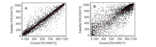
Satellite-based data vs ground-measured data
Comparison:
Most of the available radiation data is based on satellite data, which is calculated from sun radiation (satellite) as well as temperature and wind speed (weather stations). However, there is a lot of uncertainty in these calculations. Thus there are significant deviations between satellite-based data and ground-measured data, particularly when the sky is cloudy.
Another influencing fact is the area, which is considered for the data; satellite-based data refers to large areas of approx. 1 km², ground-measured data are exact.
However, the deviation is smaller when GHI is considered instead of DNI. If data for GHI and temperature from both satellite-based data and ground-measured data is correlated, good regression values can be reached: R²=0.92 and R²=0.97. If DNI and wind speed is considered, regression values show huge deviation between both measurements: R²=0.78 and R²=0.5.
It has been Albert Einstein, who discovered the physical background of photovoltaic in 1905.
Only with measurement stations on the ground you get accurate measurement data, which can be used to calculate the annual energy yield at the site. Additionally, the quality of the installed measurement instruments has to be carefully considered to get accurate measurement results, e.g., classification of pyranometers.
[The ground-measured data is based on the case study „Validation of PV Performance Models using Satellite-based Irradiance Measurements“ published by Clean Power Research.]